
Springs, Rivers, Oceans...and shipwrecks!
Rivers
The Salt River is a canal which gets its water from the Liesbeeck and Black River. The area around the Salt River was used by San hunter-gatherers and early Khoi tribes. It was one of the early frontiers to European settlement at the Cape.
The Diep River rises in the Perdeberg and Riebeeck-Kasteel Mountains. It flows in a south-easterly direction for approximately 65km. This flows towards the coast forms an extensive vlei, known as Rietvlei, which is located on the Table Bay coastline.
Westlake River, which rises on Steenberg Mountain, is also known as the Steenberg and Raapkraal River. It flows into Zandvlei, just before the suburb of Lakeside. It is known for having a variety of alien and aquatic plants and animals from the Peninsula.
Diep/Sand River system drains the southern end of Table Mountain and the area south of Wynberg Hill. The river starts at the Diep River and flows downstream, where it is known as the Sand River. The upper reaches flow through wide areas of linked public open spaces in Constantia.
The Keysers/Spaanschemat River system drains Constantiaberg and enters Zandvlei in the north-western corner. The name was in use before 1698, and commemorates Johannes Kaiser who fell into the river and drowned.
The Prinseskasteel River rises on the plateau south of Elephant’s Eye Cave on Constantiaberg. The name commemorates the legend about a Khoi princess who lived in the cave in the 16th century and was captured by Portugeuse sailors while bathing in Princessvlei. She is also commemorated through the name of the vlei.
The Hout Bay Valley runs north-south and is about 10km long and 4km wide. The main streams feeding the Hout Bay River are located on the top of Table Mountain, and descend to the valley via Orange Kloof. The two main streams are the Disa Stream and the Original Disa Stream. The drop to the Orange Kloof plain is steep and the Disa Stream plunges over waterfalls and through an area known as Hell’s Gate. Hout Bay River is also known as the Palmiet River.
The Silvermine River gets its name from attempts to mine silver in the mountains between Constantia and Fish Hoek in 1680. The Silvermine rises in the Steenberg Mountains at the southern end of Constantiabergand and flows across the Steenberg Plateau, then southward through the Silvermine Valley and enters the sea at Clovelly. The river emerges from the Silvermine Valley into the broad Fish Hoek plain.
The Kuils River doesn’t the reach the sea but empties into a system of pools. It was first named the Eerste River. The Kuils River flows to the Cape Flats. The Kuils River Valley was identified for low-cost development in early 1980's, as well as new industrial areas. Along this route, new wetlands were formed on what were farmlands.
The Liesbeeck River rises on Table Mountain above Kirstenbosch Gardens. The source of the Liesbeeck is known as Protea Stream. It was first settled by the San, then the Khoi, and then the Europeans. It was used for grazing and water. The river was named by Jan Van Riebeeck. Today, it is runs alongside the campus of St George’s Grammar School.
Ocean currents
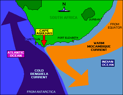
The Agulhas current is formed by the Mozambique Current and the Benguela current. This point is where the Atlantic Ocean (source of Benguela current) and Indian Ocean (source of Mozambique current) meet. These two currents affect the country’s temperature, climate and marine life species.


Some famous shipwrecks of the Western Cape
Arniston sunk: 30 May 1815
Wrecked near Waenhuiskrans
HMS Thames: 13 May 1947
Sunk in False Bay after retiring as a naval training ship near Simon’s Town
HMS Sceptre: 5 November 1799
Ran aground near the Cape of Good Hope
SS Wafra: 28 February 1971
An oil tanker grounded near Cape Agulhas. The ship later refloated and was re-sunk to avoid further contamination of the coastline.
Waterloo: 28 August 1842
A British convict ship that was driven ashore in Table Bay, with the Abercrombie Robinson, a troop transport.
Springs
The Baths (with natural hot water springs) is situated in Olifants River Valley.
Montague Springs is situated by Robertson Wine Valley and the Breede River. Avalon Springs is situated close to Montague and is a holiday resort as well. It is very similar to Montague Springs.
